Geology
Montserrat Mountain: How the Rock Formed and What Lives on It
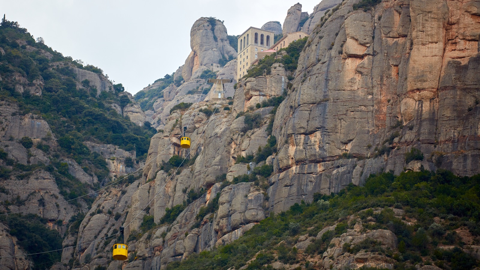
Montserrat mountain is a massif of conglomerate rock that rises abruptly from the plains of central Catalonia, about 60 km (37 miles) from Barcelona. Its highest point, Sant Jeroni, reaches 1,236 m. The rock was laid down about 40 million years ago in a fan delta, where rivers from a vanished coastal range dumped gravel at the edge of a sea. The land was later lifted and drained, and erosion stripped away the softer rock around the hard conglomerate, leaving the rounded towers and needles that give the mountain its jagged outline. Catalonia’s tourism board translates the name literally as “toothed mountain”.
Since 1987 the mountain has been a natural park, and it sits inside the Central Catalonia UNESCO Global Geopark. It is home to the Iberian ibex, Bonelli’s eagle and at least one plant found in Catalonia only here and on one neighbouring massif. This article explains how the mountain formed, how to read its skyline, what lives on it, and how to see the best of it on a day trip. The monastery, the transport and the walking routes have their own guides, linked below.
The short answer
- Rock: conglomerate, made of rounded pebbles and sand bound by a very hard limy cement, in beds that alternate with reddish sand and clay.
- Age: deposited about 40 million years ago, in the Eocene. A geological field guide by a CREAF researcher in the Catalan journal L’Atzavara gives about 40 million years; UNESCO’s description of the geopark starts its story 41 to 37 million years ago.
- Shape: the result of differential erosion, as softer rock wore away around the hard conglomerate, and of water working along the joints that split the rock.
- Highest point: Sant Jeroni, 1,236 m.
- Protection: a natural park under Decree 59/1987 of 29 January, with a Partial Nature Reserve at its core; part of a UNESCO Global Geopark designated in 2015.
- Wildlife: Iberian ibex (reintroduced in 1995), wild boar, genets, alpine swifts, wallcreepers, peregrine falcons and Bonelli’s eagles.
What Montserrat is made of
Look closely at almost any rock face on Montserrat and it is clear that this is not a smooth stone. It is packed with rounded pebbles of many sizes, set in a finer, cemented matrix. This is conglomerate, and it explains nearly everything about the mountain’s shape.
The park’s own history page describes the rock as made of pebbles, sand and a very hard limy cement. Scientists call this kind of rock puddingstone, “pudinga” in Catalan, because the pebbles sit in it like fruit in a pudding. Locally it is known as “pinyoles”.
The conglomerate is not uniform. According to the field guide by Olga Margalef of CREAF, a Catalan ecological and forestry research centre, the massif is mainly made of beds of conglomerate alternating with beds of reddish sand and clay. That layering shows on the cliffs as roughly horizontal bands. The pebbles are water-worn: they were rolled and rounded in rivers long before they came to rest here.
A delta at the edge of a vanished sea
Where those pebbles came from is the story of a coastline that no longer exists.
The CREAF field guide explains that the materials of Montserrat were laid down about 40 million years ago in a coastal alluvial fan, or fan delta, at the foot of a mountain range close to the sea. That range ran parallel to today’s Catalan coast but was much higher than the present coastal hills. Rivers pouring off it carried water and sediment from south to north, towards the central Catalan basin, which was then a sea opening to the Atlantic.
The fan was not a brief event. It stayed active for 4.4 million years. The geology notes of the Fundació Catalunya La Pedrera, written in collaboration with Catalonia’s cartographic and geological institute (ICGC), describe Montserrat as the centre of an alluvial fan where hundreds of metres of coarse material were deposited, which later became its conglomerate.
The fan sorted its load as it spread. The coarse pebbles settled nearest the mountains, and the finer sand and clay travelled further out into the basin. Montserrat’s conglomerate beds record the zone closest to the range, while the red clays record beaches and delta plains further from the source. That is also why the most solid conglomerate, with its sharp peaks and deep crevices, lies towards the centre of the massif, around the Serrat de la Portella and the Agulles.
Why the dates differ between sources
Dates for these events vary, and it is worth knowing why. UNESCO’s description of the Central Catalonia Geopark begins its story about 41 to 37 million years ago, in the Eocene, when the region lay under water that stretched towards today’s Balearic Islands. The CREAF guide gives about 40 million years for the Montserrat deposits themselves.
The natural park’s history page, written for a general audience, is looser. It speaks of a large, shallow sea gulf some 50 million years ago where the Central Catalan Depression now lies, fed by rivers carrying masses of pebbles from a vanished Catalan-Balearic massif. Both geological sources point to the Eocene and to a figure close to 40 million years, so this article follows them, and treats the park’s figure as a rounder, popular estimate of when the sea basin existed.
From sea floor to skyline
A pile of gravel at the bottom of a sea is not yet a mountain. Two further chapters turned it into one.
The first was the uplift of the whole region. During the Tertiary, as the Alpine mountain-building raised the Pyrenees to the north and the Pre-Coastal Range to the south, the basin around Montserrat filled with sediment. In UNESCO’s account, the rise of the Pyrenees made the sea retreat; it became a vast salt lake, which gradually evaporated. The CREAF guide adds that the collapse of the Neogene grabens, about 20 million years ago, finished shaping the area as it is today. The park’s page puts the emergence of Montserrat’s relief at roughly ten million years ago.
The second chapter was erosion, and it made Montserrat look the way it does. The Pedrera notes are blunt: the mountain was formed not by tectonics but by differential erosion between hard rock, the conglomerate, and softer rock, the clays and sandstones. Once the land was raised and drained, the soft beds around the massif wore away much faster than the conglomerate could. The park makes the same point: the puddingstones resist erosion far better than the neighbouring clays, sandstones and schists, and that difference, together with tectonic movements, explains the mountain’s unusual relief.
So the two accounts are not in conflict. Earth movements lifted the rock; erosion sculpted it.
How the needles were carved
Montserrat’s most famous feature is its skyline of rounded towers, needles and monoliths. They are the product of water working on a rock that is hard but cracked.
The conglomerate is split by a dense network of joints, fractures that cut through the rock. Water seeps in along them, and over long periods the joints open into gullies and chimneys, while the blocks between them are left standing as towers. The park’s history page credits the weather with the finishing work: once the relief had emerged, it was left at the mercy of wind, rain and frost.
People have always seen shapes in the result, and many of the towers carry names and legends. The Virolai, the hymn to the Virgin of Montserrat, offers the poetic explanation: little angels sawed these hills with a golden saw. The park quotes that line on its history page before setting out the scientific account.
Reading the skyline
The massif is compact enough to learn by name. The park divides it like this:
- Sant Jeroni (1,236 m) is the highest point, and the goal of the classic walk from the monastery.
- Els Ecos (1,220 m) stand on the other side of the Coll de Migdia, the pass that separates them from Sant Jeroni.
- The Coll de Migdia, with the pointed Talaia at its centre, divides the range into two almost equal halves.
- The eastern half takes in Santa Magdalena, the Serres de Santa Maria, Sant Salvador and the Flautats, including the well-known Cavall Bernat monolith.
- The western half takes in Els Ecos, the Frares Encantats (the “enchanted friars”) and the filigree of the Agulles (“the needles”), with the Coll de Port.
Geologically, the massif belongs to the Catalan Pre-Coastal Range, even though from the plains it looks like a mountain entirely on its own.
The quieter side of the massif
Most visitors see Montserrat only from the monastery. The side above El Bruc feels different. Coll de Can Maçana, in the municipality of El Bruc, covers almost 7% of the natural park and is the main way into the trails and rocky peaks of this lesser-known part of the mountain, where the monoliths form a maze of vertical shapes. Around the pass, the outcrops are clay and layers of sandstone and conglomerate; walk towards the Serrat de la Portella and the Agulles and the rock becomes the more solid, sharply pinnacled conglomerate of the core. A walk from the pass into the Agulles shows the change in the rock for yourself.
The view from the top
On a clear day the summit of Sant Jeroni gives one of the great panoramas of Catalonia. The park describes a view that reaches from the Pyrenees to the sea, and says that on days of exceptional visibility you can even see Mallorca.
You do not have to climb to the summit to understand the mountain’s shape. The Sant Joan funicular lifts you from the monastery to viewpoints above it, and the natural park’s signposted route continues from there to Sant Jeroni. Our guide to hiking Montserrat has the distances, times and what to bring.
The view depends on the weather. Low cloud can hide it completely, so if the panorama matters to you, check the forecast before you go.
A protected mountain
Montserrat’s protection has built up over three quarters of a century:
- 1950: a decree-law of 16 October created the Patronat de la Muntanya de Montserrat, the public body that manages the mountain.
- 1987: Decree 59/1987 of 29 January declared the mountain a natural park, to protect the singularity of its relief and its geological, plant, animal and landscape values.
- The reserve: within the park, the same decree created a Partial Nature Reserve to give absolute protection to the geological and geomorphological formations.
- Geological interest: the whole mountain is listed as a Space of Geological Interest, geozone 224.
- 2015: the Central Catalonia UNESCO Global Geopark, which takes in Montserrat, was designated.
As for size, Catalonia’s tourism board lists the park at 3,630 hectares and gives 1987 as its declaration date. It is a compact area for such a well-known landmark.
Plants: a mountain of holm oak
From a distance Montserrat looks like bare rock. Up close it is surprisingly green. The park describes it as above all a mountain of holm oak woods, with lush vegetation on the ledges and, above all, in the gullies.
- Holm oak dominates the lower slopes, with laurustinus, box, ivy and strawberry tree beneath it.
- Sunny slopes carry aromatic scrub of rosemary, thyme and winter heath.
- Plateaus between 800 and 1,200 m, such as the area around Sant Jeroni, hold the few montane holm oak woods, where herbs take the place of shrubs.
- Rock faces shelter specialists. The saxifrage called corona de reina (Saxifraga callosa subsp. catalaunica) is found in Catalonia only here and at Sant Llorenç del Munt.
The dense, shaded woods also hold small stands of deciduous oak and even yew, in the coolest and most sheltered spots. It is this mix of dry, sunny rock and cool, damp gullies, side by side, that makes a small mountain botanically rich.
Animals: ibex, eagles and cliff birds
The park is candid that human activity and the spread of built-up areas around Montserrat caused decades of decline in native wildlife, and that the great fire of 1986 made it worse. Since then nature has gradually recovered its balance, and the fauna today is mainly Mediterranean, with some species more typical of central Europe in parts of the range.
- Iberian ibex. Since its reintroduction in 1995, the ibex has again become part of Montserrat’s landscape. Keep an eye on the ledges.
- Mammals. Wild boar, red squirrels, stone martens and common genets are characteristic.
- Cliff birds. Alpine swifts, crag martins and the wallcreeper use the rock walls.
- Birds of prey. Bonelli’s eagle, listed as vulnerable, nests on cliffs between February and June; the peregrine falcon breeds between March and May.
- Other birds. Catalonia’s tourism board adds alpine accentor, blue rock thrush and rock sparrow to the species worth looking for.
Why some climbing routes close in spring
Those nesting seasons have practical consequences. The park sets temporary climbing restrictions during the breeding period and asks walkers and climbers to respect its signs and seasonal rules, since quiet around the nest sites is essential. If a crag is closed when you visit, nesting birds are one of the reasons the park gives.
Seeing the mountain on a day trip
Most visitors see Montserrat’s geology without trying: the rack railway and the Aeri cable car both climb past the cliffs to reach the monastery, and the Sant Joan funicular carries on higher. A few ways to see more:
- Look out of the window on the way up. From the rack railway or the Aeri you pass close enough to the rock to see that it is made of pebbles.
- Take the Sant Joan funicular from the monastery for views over the massif and the plains. Beside its upper station, the park’s Aula de Natura explains the mountain’s history, fauna and flora.
- Walk among the towers on the park’s hermitages route or on the way to Sant Jeroni.
- Choose a day with time to spare. The half-day small-group tour from Barcelona includes free time on the mountain, and the Tot Montserrat ticket lets you travel at your own pace, with lunch on the mountain.
Our guide to getting to Montserrat compares the train, rack railway, Aeri, coach and car, and our comparison of Montserrat tours from Barcelona weighs the guided options against going alone.
Walking lightly in the park
- Stay on marked paths; the towers are for equipped climbers, not walkers.
- Respect seasonal closures for nesting birds.
- Take your litter home and leave plants and rocks where they are.
- Carry water and sun protection, as the upper mountain has little shade.
Frequently asked questions
How was Montserrat mountain formed?
Its conglomerate was deposited about 40 million years ago in a fan delta, where rivers from a higher coastal range dumped pebbles at the edge of a sea. The region was later lifted and drained, and differential erosion removed the softer rock around the hard conglomerate, while water working along the joints carved the towers.
How high is Montserrat?
The highest point is Sant Jeroni, at 1,236 m. Els Ecos, across the Coll de Migdia, reach 1,220 m.
Is Montserrat a volcano?
No. It is sedimentary rock: conglomerate of rounded pebbles and sand bound by a limy cement, laid down by rivers. Its shape comes from erosion, not from eruptions.
What does the name Montserrat mean?
Catalonia’s tourism board translates it literally as “toothed mountain”, a fitting name for the jagged line of rock towers. The Virolai hymn tells the poetic version, with angels sawing the hills with a golden saw.
Can you see ibex at Montserrat?
Yes, they live on the mountain. Iberian ibex were reintroduced in 1995, and the park says they have again become part of Montserrat’s landscape.
When did Montserrat become a natural park?
In 1987, by Decree 59/1987 of 29 January, which also created a Partial Nature Reserve at its core. The Central Catalonia UNESCO Global Geopark, which takes in the mountain, was designated in 2015.